By Mitch Paine, CFM
From March 2016 Floodplain Management Today
Of all natural hazards, flooding affects the most people and property every year. Even though the problem of flooding seems prevalent to some people, much of the general public doesn’t realize the risk that flooding poses. One of our roles as floodplain managers is to help the public, particularly those who live in flood risk areas, understand the risk, grasp the reality, and prepare their families for the inevitability.
Many people have trouble understanding flood risk because they have never experienced, seen, or heard of it in their community before. A common phrase we all hear is “we’ve never had flooding here before, why should we have to build our house up?” We can’t, of course, go back and create flooding to show people what it looked like when flooding actually did occur. But, we can show people aspects of historical floods to help the public visualize history.
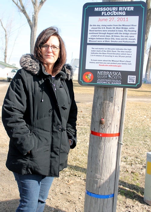
The Highwater Mark Campaign, an initiative of the Nebraska Silver Jackets team, aimed to do just that, show people historic flood levels from “the big flood” in history. In Omaha that big flood was 1952, in Lincoln it was 1908, and in Schuyler it was 2008. The big flood may be out of the memories of some or all of a community, but we can ensure fewer people are harmed during the next flood by reminding the community members of significant historical events. Highwater marks are important tools in studying flood history and flood risk. They help engineers understand the characteristics of large flood events.
Nearly 20 highwater mark signs were requested by communities across the state from Omaha to Hooper to Scottsbluff. These signs are placed in prominent locations that will connect real events in history to modern-day flood risk. On each of the signs reads a story from a flood event in that community’s history. For example, in Louisville, the Mill Creek flood of 1923 remains the deadliest flood in the city. The sign reads, “September 28, 1923: On this day, a cloudburst storm sent water from Mill Creek overflowing its banks in Louisville. Almost every business on Main Street was flooded. When the waters subsided, 3 houses were swept away and 12 people had died. The flooding left mud measuring from 4 inches to 1-foot deep in many homes and businesses.”
The sign located in Bellevue along the Missouri River reads, “April 7, 1952: On this day, 20 families evacuated from nearby homes as the Missouri River rose from Niobrara to Rulo, Nebraska. There were similar evacuations in 1960, 1962, and 1984. On June 18, 1990, nearly 30 homes had floodwater up to 4 feet deep at the Iske Park and Holub’s Place Subdivisions.
After flooding damaged the same homes in 1993, many were bought and removed by the Papio-Missouri River Natural Resources District.” At this location, a surveyed elevation marker will show visitors the height of the floodwaters in 2011 as well as the height of the base flood elevation.
An electronic code on each sign will take the visitor to a website where they can learn more about flood history and flood safety. This project will hopefully help the average citizen better understand flood risk around the state and contribute to better individual and community decisions about flooding. The highwater mark signs were printed by the US Army Corps of Engineers – Omaha District and put together by the USACE and the other agency partners that make up the Silver Jackets team: NeDNR, the Nebraska Emergency Management Agency, the National Weather Service, the US Geological Survey, and local communities.
Visit the following site to learn more: http://floods.dnr.nebraska.gov.