Floodplain Mapping Categories
The Floodplain Management Division at the State of Nebraska works in partnership with the Federal Emergency Management Agency (FEMA) to produce floodplain mapping products in adherence to National Flood Insurance Program (NFIP) requirements and regulations.
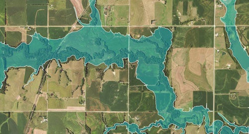
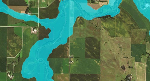
Mapping determined using approximate methodologies which defines areas subject to 1%-annual-chance flooding (Zone A) and 0.2% annual-chance flooding (Shaded Zone X). Basic mapping does not consider structures, but is based only on bare earth topography.
Because detailed hydraulic analyses have not been performed, no Base Flood Elevations (BFEs) or flood depths are shown. Mandatory flood insurance purchase requirements and floodplain management standards apply.
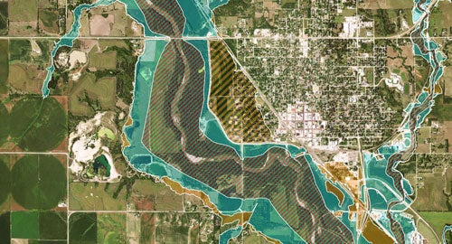
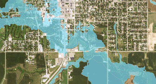
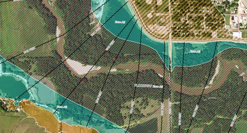
Mapping determined using detailed methods which defines areas subject to 1%-annual-chance flooding (Zone AE) and 0.2%-annual-chance flooding (Shaded Zone X). Enhanced study areas show Base Flood Elevations (BFEs) on the maps and typically define a Floodway.
A floodway reserves land adjacent to the stream to convey the 1%-annual-chance-flood event without cumulatively increasing the base flood elevation more than one-foot. Communities must regulate development within the floodway to ensure there are no base flood elevation increases.
Flood Awareness Areas are floodplain boundaries that are produced by the Nebraska Floodplain Management Division which can be used as “best available data” for communities involved in a current mapping project, those that do not have regulatory floodplain boundaries, or those that have outdated floodplain information.
The Nebraska Floodplain Management Division delineates flood awareness areas to provide communities with the most accurate flood risk information. These flood awareness areas can be viewed on our Floodplain Interactive Map.
Products that Convey Flood Risk
The Nebraska Floodplain Management Division works in partnership with the Federal Emergency Management Agency (FEMA) to help community members and officials view and visualize their local flood risk, allowing communities to make informed decisions about reducing flood loss and mitigating potential damage from flood hazards.
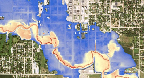
DFIRMs are FEMA products that depict areas prone to flooding during the 1%-annual-chance flood (Zone A / Zone AE) and the 0.2%-annual-chance flood (Shaded Zone X). DFIRMs are considered regulatory products for communities to use for floodplain management and for flood insurance rating purposes. DFIRMs can be viewed or downloaded from the FEMA Map Service Center.
The Nebraska Floodplain Management Division's Role: We partner with FEMA to conduct floodplain mapping to update the DFIRM products for areas prioritized through the FEMA RiskMAP program. FEMA provides financial support for us to conduct these studies, which allow us to meet our statutory responsibilities to provide flood risk data and promote effective floodplain management to the citizens of Nebraska.
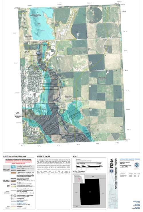
The FIS explains the study methods used in creation of the floodplain boundaries, as shown on DFIRMs. It also contains profiles for enhanced study areas. FIS documents can be downloaded from FEMA’s Map Service Center.
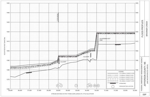
A BFE is the height that flood waters are anticipated to reach at a given location in the event of the 1%-annual-chance flood (base flood). The FIS, not the DIFIRM, should be used to determine BFEs in enhanced study areas. For areas mapped using approximate methods, BFEs need to be determined using FEMA accepted methods.
In certain instances, the Nebraska Floodplain Management Division provides BFE Determinations to Floodplain Administrators, upon request, for distribution to stakeholders applying for permits for Letters of Map Changes. If you are a Floodplain Administrator and would like to request a BFE, click here. If you are a homeowner, lender, engineer, or contractor and wish to request a BFE, please contact your Floodplain Administrator.
LOMCs are documents that depict changes made to DFIRMs because of revised flood studies or updated information in a localized area. LOMCs are often submitted due to updated engineering data, construction of a flood risk reduction project, or to clarify the floodplain map at locations, such as at one particular residence, too small to be seen on a map.
Digital Work Maps are floodplain maps that are produced by the Nebraska Floodplain Management Division which can be used as best available data for communities that do not have DFIRMs or those that have outdated DFIRMs. The Nebraska Floodplain Management Division produces work maps to provide communities with the most accurate flood risk information.
The maps are created using FEMA mapping standards, so communities have the option of adopting the Work Maps for local planning and building purposes, while also using FEMA regulatory products. These work maps can be viewed on our Floodplain Interactive Map.
As part of new floodplain mapping projects, additional products are created to show more detail than just the 1% and 0.2%-annual-chance flood boundaries. These products give communities information related to depth of flood water, probability of flooding occurring at a specific location each year, probability of flooding occurring at a specific location over the course of a 30-year mortgage, areas of mitigation interest, and changes in floodplain boundaries from the previous FEMA FIRMs.
Click here to view the FEMA Risk MAP Flood Risk Products. To view Flood Risk products available in Nebraska, please visit our Interactive Map.
Business Plan
As part of the Cooperating Technical Partners (CTP) agreement with FEMA, the Floodplain Management team is tasked with developing a vision for mapping priorities for at least three-years into the future. The Nebraska Floodplain Management Division works to sequence projects in our business plan in a logical manner to address existing mapping needs. Projects are selected at a watershed level and, when possible, the Nebraska Floodplain Management Division is leveraging the work of other agencies to avoid overlapping efforts and to maintain cost-efficiency. This allows us to maximize funding opportunities to provide more of the state with updated, high-quality regulatory products.
2020 Nebraska Levee Inventory
The Department of Water, Energy, and Environment combined information from the U.S. Army Corps of Engineers (USACE) National Levee Database, Federal Emergency Management Agency (FEMA), Nebraska Emergency Management Agency (NEMA), Natural Resources Districts (NRDs), Emergency Managers, local communities, and our Floodplain Management Program to develop the 2020 Nebraska Levee Inventory, and to identify levees that were damaged during the 2019 flooding (Figure 1). Figure 2 shows the repair programs that are supporting recovery efforts for the Nebraska levees damage by the 2019 flooding. Since most levees are located in the eastern portion of the state, which was the area most heavily impacted by flooding in 2019, a map was created to display those damaged levees located in eastern Nebraska (Figure 3).