
Current Projects
- Integrated Water Management Current Projects handout (November 2012)
- Integrated Water Management in Nebraska: Current Projects (Water Matters No. 7, October 2012)
Model and Study Areas
- Place cursor over a model name or study name (listed above map) to view the corresponding research area.
- Place cursor over a data category (listed below map) to view statewide data.
- Click on a model or study name, or on the corresponding research area on the map, for more information about each model or study.
Why Does the Department Use Hydrologic Models?
The Nebraska Department of Water, Energy, and Environment (the Department) has developed several hydrologic models to assist with water management across Nebraska by providing a better understanding of regional hydrogeology and water availability. Each model was developed through collaborative efforts with local natural resources districts (NRDs) and stakeholders. By assisting with the assessment of the impacts of water use and management practices on long-term water supplies, the Department’s hydrologic models play an integral role in the planning and management of Nebraska’s water resources to meet the objectives of local integrated management plans (IMPs), basin-wide plans, state legislation, and interstate water agreements.
Some specific applications of the Department’s hydrologic models include:
- Simulating surface water-groundwater interactions in support of the Department’s annual evaluation of the availability of hydrologically connected water supplies (i.e., the fully appropriated basin (FAB) analysis),
- Reproducing historic trends under varying hydrologic and hydrogeologic conditions,
- Helping water administrators understand the short-term and long-term balance between water supplies and demands
- Analyzing depletions of hydrologically connected surface and groundwater supplies, and
- Projecting the cumulative effects of water use and water management decisions on each region’s total water supply.
Hydrologic models are tools that have been widely used to facilitate understanding of hydrologic systems over vast areas.
Model Development and Operation
Several models have been developed and applied across the state of Nebraska, as shown in the figure above. All of the Department’s models use similar input data, including land use, stream flow, pumping rates, and aquifer properties such as total water storage and water delivery rates. In basins with significant surface water use, such as large reservoirs or significant surface water diversions, these additional model aspects are also included. Model input data are derived by incorporating a groundwater flow model, such as USGS MODFLOW, with CROPSIM, a water-driven, soil water-balance point model used to investigate the system response to different forms of vegetative growth.
While the inputs, outputs, and objectives of each model differ somewhat due to specific local data needs and regional hydrogeologic differences, they all provide information about how surface water and groundwater interact and move through the hydrologic cycle.
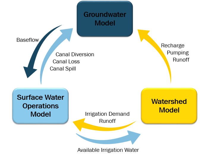
Each hydrologic model is based on the Department’s integrated water management modeling framework, which operates through the integration and interaction of three different models: a watershed model, a surface water operations model, and a groundwater model. Each of these three models is first operated independently, and then integration occurs through a series of data processing and transfers, as shown in the figure below:
Additional information is available about each model or study area:
- Blue Basin Model
- CENEB Model
- COHYST Model
- Lower Platte/Missouri Tributaries Model
- Nemaha Model
- Republican Basin Study
- Upper Niobrara-White Model
- Western Water Use Model
