Program Information
PLATTE RIVER RECOVERY IMPLEMENTATION PROGRAM
July 7, 2008
The Platte River Recovery Implementation Program (Program) is a basin-wide effort undertaken by the Department of the Interior (DOI) and the States of Colorado, Nebraska and Wyoming to provide benefits for the endangered interior least tern, whooping crane, and pallid sturgeon and the threatened piping plover. Through the Program, the states and federal government will provide land, water and scientific monitoring and research to evaluate Program benefits for the target species. The implementation of the Program is incremental with the first increment designated for 13 years.
Program History
On July 1, 1997 the Governors of Nebraska, Colorado and Wyoming and the U.S. Secretary of Interior signed a cooperative agreement outlining a proposed basin wide recovery implementation program for endangered species in the Central and Lower Platte Basins. Thereafter a Governance Committee began formulating details of the Program. In 2006, the U.S. Bureau of Reclamation released a Final Programmatic Environmental Impact Statement and the U.S. Fish and Wildlife Service issued a final Biological Opinion. Secretary of Interior Dirk Kempthorne then signed the Record of Decision supporting the Program. In October 2006 Nebraska Governor Heineman signed the formal document agreeing to the Platte Recovery and Implementation Program and work officially commenced on January 1, 2007. The President signed legislation providing Federal Program approval on May 8, 2008.
Program Implementation Responsibilities
Implementation of this Program will be through a Governance Committee (GC) consisting of representatives of the three states, DOI, water users and environmental groups. Jennifer Schellpeper of the Nebraska Department of Natural Resources serves as the Nebraska state representative to the Governance Committee and Kirk Nelson of the Nebraska Game and Parks Commission serves as the alternate.
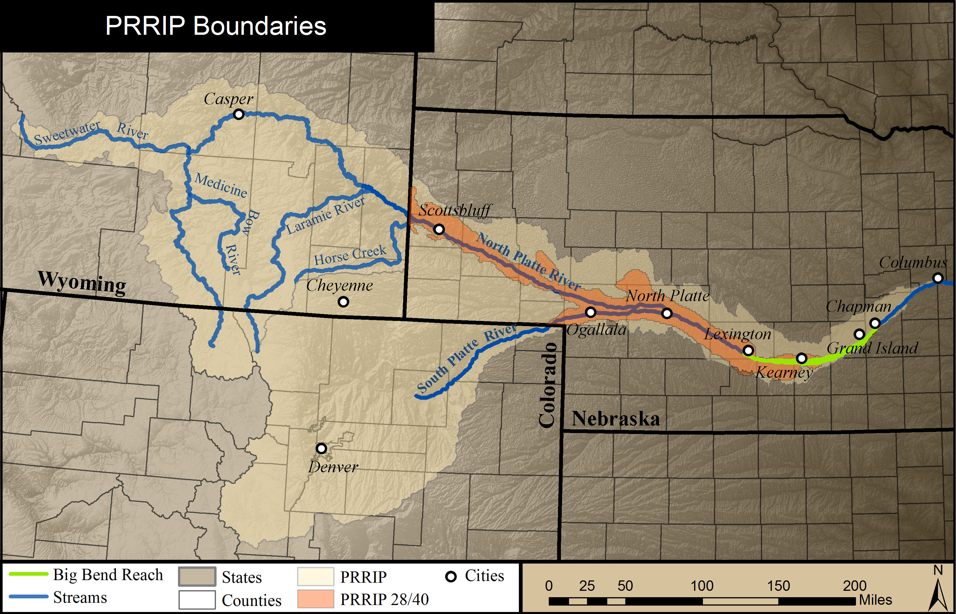
The Program proposes to reduce shortages to U.S. Fish and Wildlife Service target flows and provide additional land habitat for endangered species in the Lexington to Chapman reach of the river. Portions of the shortages to target flows will be obtained through water conservation and water supply projects identified by the Governance Committee in the water action plan. The contracting process for assessment of project assessment feasibility and impact to target flows has begun.
During the first increment of the Program, progress toward Program objectives for Endangered Species Act compliance purposes will be measured through the achievement of ![]() Milestones. There are currently ten milestones including operation of the depletions plans of the three states and the Federal government during the Program's first increment. By various times the first increment is also to include construction and operation of the Tamarack I project, operation of the Pathfinder modification project, implementation of a reconnaissance level water action plan, implementation of an Environmental account for storage reservoirs, implementation of a land plan, and implementation of a integrated monitoring and research plan .
Milestones. There are currently ten milestones including operation of the depletions plans of the three states and the Federal government during the Program's first increment. By various times the first increment is also to include construction and operation of the Tamarack I project, operation of the Pathfinder modification project, implementation of a reconnaissance level water action plan, implementation of an Environmental account for storage reservoirs, implementation of a land plan, and implementation of a integrated monitoring and research plan .
Depletion Plans
One of the Program's purposes is to mitigate the adverse impacts of certain new water related activities through the implementation of state and federal depletions plans. The depletion plans of the states and the federal government call for each state to mitigate, offset, or prevent any new depletion to the river's target flows as part of the proposed program. Each state, including Nebraska is charged with getting back to a July 1, 1997 level of development of water use and associated river depletions. New or expanded uses which result in stream flow depletions need to be offset. This will allow continued growth and water development to occur in the Platte River basin along with improving conditions for the target species.
In Nebraska, the responsibility of implementing the new depletion plan is shared between the State of Nebraska and the Platte River Natural Resources Districts. Efforts to offset depletions are being carefully coordinated with Nebraska's Integrated Management Plan activities being conducted to carry out provisions of the Ground Water Management and Protection Act. The amount, timing and location of depletions caused by new irrigation uses of hydrologically connected ground water have been identified and reported to the Governance Committee. The state is still determining the depletions caused by other uses.
Program Elements
The Program has three main elements: (1) increasing streamflows in the central Platte River during relevant time periods through retiming and water conservation/supply projects; (2) enhancing, restoring and protecting habitat lands for the target bird species; and (3) accommodating certain new water related activities. The Program will achieve these elements through an adaptive management approach employing scientific monitoring and research to evaluate the management actions and species habitat needs. These elements will be implemented according to underlying principles that require interests in land to be acquired only from willing participants and avoid increasing tax burdens to local citizens by paying taxes or their equivalent on Program lands. Program lands will be held by a land holding entity (rather than by the federal or state governments) and will be managed under a "good neighbor" policy. The adaptive management plan is being closely managed by the adaptive management working group. This group is composed of members from the other advisory committees.
Water
The Program's long-term objective for water is to provide sufficient water to and through the central Platte River habitat area to assist in improving and maintaining habitat for the target species using incentive based water projects. During the First Increment (13 years) the Program's objective is to retime and improve flows in the central Platte River to reduce shortages to target flows by an average of 130,000 to 150,000 acre-feet per year at Grand Island. Guidance in implementing the water component of the Program is provided in the Program's ![]() water plan. A water advisory committee (WAC) was formed as part of the Program to provide assistance and advice on water related matters as directed by the GC. Items that may be reviewed include the annual operating plans for Program water and environmental account water, individual state tracking, accounting and protection of Program water and review of the water action plan projects. The WAC includes membership from each of the same entities who compose the GC.
water plan. A water advisory committee (WAC) was formed as part of the Program to provide assistance and advice on water related matters as directed by the GC. Items that may be reviewed include the annual operating plans for Program water and environmental account water, individual state tracking, accounting and protection of Program water and review of the water action plan projects. The WAC includes membership from each of the same entities who compose the GC.
Land
During the First Increment the Program's objective is to protect, restore, and maintain 10,000 acres of habitat. The Program's long-term objective for land is to acquire land interests, restore where appropriate, and maintain and manage approximately 29,000 acres of suitable habitat along the central Platte River between Lexington and Chapman, Nebraska. Land acquired during the Program's First Increment will be credited to this long-term objective as will certain lands that meet criteria established by the Governance Committee but are managed by other entities such as environmental organizations or utility and irrigation districts. Guidance in implementing the land component of the Program is provided in the Program's ![]() land plan. A land advisory committee (LAC) will carry out a number of activities to assist in the land plan's implementation, generally coordinated or in collaboration with the Program's Executive Director. The LAC will also provide meaningful local input into decisions about operations of the land component, including making recommendations to the Governance Committee about how the Program can both be a "good neighbor" and effectively further the purposes of the Program. The Committee includes membership from each of the same entities who compose the GC with three landowners from Nebraska appointed by the Central Platte and Tri-Basin Natural Resources Districts.
land plan. A land advisory committee (LAC) will carry out a number of activities to assist in the land plan's implementation, generally coordinated or in collaboration with the Program's Executive Director. The LAC will also provide meaningful local input into decisions about operations of the land component, including making recommendations to the Governance Committee about how the Program can both be a "good neighbor" and effectively further the purposes of the Program. The Committee includes membership from each of the same entities who compose the GC with three landowners from Nebraska appointed by the Central Platte and Tri-Basin Natural Resources Districts.
Cost and Cost Sharing
The total burden of the program in terms of monetary, water, and land contributions is to be shared equally by the United States and the three States (50% Federal/50% States). The estimated monetary cost of the first thirteen year increment of the Proposed Program is $187 million. The federal administration has agreed that the federal share of that cost should equal $157 million. Congress authorized the Program and has appropriated funds for the next fiscal year. Colorado and Wyoming have been making cash contributions as it has been needed to carry out the work of the GC. Nebraska will receive enough credit for the water and land contributions being made by Central Nebraska Public Power and Irrigation District and Nebraska Public Power District so that no cash will be required from Nebraska for any portion of the $187 million. However, Nebraska will have substantial costs in offsetting depletions caused by new or expanded uses begun after July 1, 1997.
Program Documents
 Implementation Program
- De Minimus Determinations
- Guidance for Water-Related Projects in Nebraska
- NRCS Consumptive Use Calculator Report
 NRCS Consumptive Use Calculator (.xls)
Nebraska New Depletion Plan Annual Reports and Updates
- 2020 Report | *
- 2019 Report | 2019 Update
- 2018 Report | 2018 Update
- 2017 Report | 2017 Update
- 2016 Report | 2016 Update
- 2015 Report | 2015 Update
* As of 2020, annual updates will not be provided; activities and results will be reported to the GC as they are available.
Meeting Information
Maps
- Requests for Proposals
- Websites
- PRRIP Presentation (March 2008) | Printer friendly version
- CNPPID Platte River Program Status (Feb. 2006)
- Contact Us
- Jennifer Schellpeper, Nebraska Department of Natural Resources
- Phone: 402-471-2899
- E-mail: Platte River Recovery