
Project Overview
The Nebraska Department of Natural Resources (NDNR), Central Platte Natural Resources District (CPNRD), and Nebraska Public Power District (NPPD) have entered into an agreement to evaluate and investigate opportunities to prepare a potential plan to conjunctively manage the surface and ground water resources of the Central Platte Valley. The concept of conjunctive management is that surface and ground water resources are hydrologically interconnected, and decisions to improve the management of one can’t be made properly without considering the other. Hence management should consider surface and ground water as components of one resource.
The Project will proceed in three phases. Phase one of the plan gathered substantial background information, and funding requirements to proceed with phase two objectives. Phase two, which is currently underway, will create the tools necessary to evaluate conjunctive management strategies. Phase three will identify those strategies to be implemented and evaluate methods of implementation.
Nearly 200,000 acres of highly productive farmlands in the Central Platte Valley, in Dawson and western Buffalo Counties of Nebraska, are irrigated by surface and ground water (Figure 1). The surface water irrigation dates back to the 1880s and is supplied by senior natural flow rights in the Platte River augmented by storage water from Lake McConaughy. Ground water comes from alluvial and the Great Plains aquifers, which are productive and which contain a large volume of stored water. Use of ground water has grown substantially over the past 40 years, to the point that there are now nearly 3,000 large wells in the area (and more than 18,000 irrigation wells for the Central Platte NRD as a whole). Total irrigation diversions to serve lands in Dawson and western Buffalo Counties exceed 400,000 acre-feet per year.
Objective
The plan’s focus will be on benefits to water users -- ensuring and optimizing supplies to users of ground water and surface water who are within both the boundaries of the CPNRD and the area within which NPPD delivers natural flow and storage water for surface water irrigation system. Embedded in the purpose is the objective of informing and educating the public concerning the surface water and ground water resources of the project area and the effects and impacts of changes in water supply or use on the people and resources of the State of Nebraska. The conjunctive management plan is a flexible complement to the IMP. The flexibility arises because procedurally the conjunctive plan is not governed by State law, and substantively it does not have any legally required outcome.
Potential Problems To Be Examined
- Effects of Droughts on Water Supply- Recent droughts have led to the widespread recognition of the scientific fact that surface water supplies are not 100% reliable. The possibility exists that surface water deliveries may decrease as farmers turn instead to ground water (e.g. on lands where both supplies are potentially available). This over reliance on ground water will cause additional depletions of the aquifer.
- Canal Recharge Benefits- Recharge from irrigation canals and farms are the most important source for replenishing the ground water. Curtailing surface water use could harm ground water supplies. Recharge also benefits surface flows, since ground water baseflow is an important source of river water, especially in dry periods.
- Groundwater Pumping Depletions- Ground water pumping causes depletion of river flows. Although the effect is not instantaneous, it is lagged over time which means that the full effects from existing wells have not reached the Platte River. Also, if pumping exceeds recharge over the long-term, the result will be exhaustion of the aquifer.
- Platte River Cooperative Agreement- The Federal government has concluded that certain levels of Central Platte streamflows are needed to maintain habitat for endangered species. A Platte River Recovery Implementation Program that involves Nebraska, Wyoming, Colorado, and the Department of the Interior will alter water management of the Platte River, but has yet to produce a final plan to maintain streamflows. The program document has already been signed by the Governors of Nebraska and Colorado and the Secretary of the Interior. The Governor of Wyoming is expected to sign soon. The program will ensure a basin-wide fair share approach to ESA (Endangered Species Act) compliance and provide ESA coverage for all existing water uses above Columbus. Key elements of what has occurred, or is likely to occur, include use of reservoir and sub-surface storage to re-time streamflows; and requirements to limit or offset increased depletions of streamflow from water uses developed or expanded after July 1, 1997. The return to a 1997 water balance could be required in just a few years.
- LB962 Legislation- Nebraska law now provides that most ground water that is hydrologically connected to the Platte River is fully appropriated (as of July 17, 2004) or, in some-cases, over-appropriated. Hydrologic connection exists where pumping will cause a streamflow depletion within 50 years greater than 10% of the pumping rate. In the Central Platte that area is likely to include all of the actively irrigated areas in Figure 1.
- Nitrate Contamination- Fertilizers used on farms have caused severe nitrate contamination of the aquifer in some areas, especially from areas not benefited by canal recharge. In affected areas, CPNRD has a phased program that requires measures such as controls on fertilizer use; the controls are increasingly stringent in proportion to the level of contamination.
- Integrated Management- The CPNRD and NDNR are required to do an Integrated Management Plan (IMP) for the Central Platte Valley that, in effect, constrains water uses so they are in balance with supplies. That portion of the area above Kearney Canal is considered over-appropriated; there the IMP must reduce uses of water at least to levels that existed in 1997 -- more if needed to achieve a hydrologic balance.
Collectively these conditions require that uses of available surface and ground water not exceed the long-term supply. Specific priorities clearly include sustaining the agricultural economy, which in turn requires making effective use of the sustainable surface water and ground water supply while also maintaining streamflows at required levels.
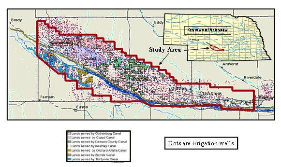
Figure 1. Map showing lands in study area irrigated by surface water, and location of wells used for irrigation.
