
Taken from "Nebraska Geographic Information Systems Steering Committee - Gis Technical Standards" December 15, 1993, version.
Chapter 1. Introduction
A geographic information system (GIS) is a computer based system capable of processing data describing locations on the earth's surface. More formally, a GIS system allows users to efficiently capture, manage, manipulate, analyze, and display geographically referenced and associated attribute data. GIS technology assists in integrating information in a way that helps us understand and address some of the most pressing problems we face today -- deforestation, acid rain, rapid urbanization, natural resource management, demographics, spread of disease, fires, and floods, to name a few. It provides a basis for making timely and intelligent decisions by helping us to organize data about these problems and to understand their spatial relationships.
Geographic information system has multidisciplinary applications. Natural resources, geographic, medical, sociological, military, and earth science activities among others require extensive spatial data analysis. Spatial data sets are frequently heterogeneous, having data elements such as soils, land use, streams, roads, and population statistics, and are often comprised of data sources with different scales, coordinate systems, and collection agencies. The variety of possible GIS applications and users, and the constant evolution of GIS technology makes it impractical and inappropriate to generate strict criteria for GIS implementation. However, for the same reasons, compatibility and standardization of GIS systems becomes critical to provide conceptual integrity, data sharing, and foresight into the future.
This technical document describes the applicable standards and recommendations for a geographic information system in relation to the required GIS functionality. It can help the managers and decision makers analyze their GIS requirements, evaluate a GIS system based on those requirements, use it as a guideline for implementation and procurement of a GIS computer system, and avoid potential incompatibilities and inoperabilities.
The document identifies current standards from the GIS developers' perspective and then discusses GIS elements from the users' perspective -- GIS software functions, hardware components, networking protocols, spatial data transfer standard, data capture standards, and cartographic production guidelines. Due to the evolving nature of GIS and computer technology, this document with refinements will also evolve to stay current with the state of the art.
The reader is urged to perform a user requirement analysis -- reviewing the traditional methods, identifying GIS capabilities to meet the same requirement, and the possibilities of improving current capabilities of their organization. After a comprehensive assessment of the analytical capabilities and products required by potential users of GIS, the requirements can then be matched with the software functions and the hardware elements described in this document. The reader can then review various GIS software products based on the software functions and the hardware components supported and perform a cost/benefit analysis. The selection of a GIS software also dictates the minimum and recommended hardware platforms. In this document, effort has been made to categorize and relate the software functionality with the hardware requirements. However, the software vendor's recommendations and the experiences of other users using the same software should also be considered when making a decision about appropriate GIS hardware.
GIS Application Classes
Following is a taxonomy of GIS applications done by Michael F. Goodchild . Each class includes brief comments on functional requirements and a summary describing the application in terms of functionality, data volume, and access speed.
Natural Resources Management
GIS is a cost-effective means of analyzing data in support of many forestry applications (timber yield estimations), computing soil erosion and modeling groundwater level and quality. Three operations are particularly significant in explaining these interest in GIS applications for natural resource management: area measurement, superimposition and analysis of maps of different themes (e.g., soils and forest types), and the generation of buffers of specified width around map features, such as streams.
Functionality: high -- data analysis often is complex.
Volume: not large by comparison -- few gigabytes is common.
Access speed: relatively unimportant -- much output is in report or map form.
Infrastructure Management
Organizations that maintain complex infrastructure need the ability to track and manage installations geographically. For example, it is important for a utility company to know service request locations to schedule its crews efficiently. "One-call" services that provide information on underground infrastructure rely on geographical records access to answer queries about existing facilities within range of proposed construction projects. Major customers for infrastructure GIS include utilities, transportation departments, railroads, and city and county engineering departments. The term AM/FM (automated mapping/facilities management) often is used for infrastructure GIS applications. Functionality: not high -- queries are generally "what is here?" or "where is it?" Volume: large -- may reach hundreds of gigabytes. Access speed: fast -- prompt query response is required. Land Information Systems Land information systems maintain data on individual ownership parcels and associated attributes relevant to assessment and taxation. The term "multipurpose cadastre" refers to a parcel-level database used to support a wider array of applications, such as infrastructure management.
Functionality: not large -- queries are generally limited to attribute retrievals, and the database also is used for simple mapping.
Volume: large -- may reach hundreds of gigabytes.
Access speed: fast -- prompt query response is required.
Vehicle Routing and Scheduling
The U.S. Census Bureau's TIGER database has led to renewed interest in using GIS to track vehicles; plan services, such as garbage collection; and even dispatch taxicabs. All of these applications rely on a simplified representation of a route network. Vehicle navigation aids, for example, can display a continuously updated route map.
Functionality: not high -- limited to a few simple commands. Volume: not large -- the entire U.S. street network numbers in the tens of gigabytes. Access speed: fast -- prompt query response is required.
Marketing and Retailing
Location is important in determining the success or failure of a retail establishment, so it is not surprising that geographical factors play a significant role in retail analysis. Key functions include geocoding, the ability to generate coordinate locations from street addresses and find them on a map; points in polygon operations to identify the reporting zone (e.g., ZIP or county) containing a customer's location; and polygon overlay to transfer estimates of population counts between two sets of incompatible reporting zones. Similar functions now are being used in crime analysis and in epidemiology to tract disease patterns.
Functionality: high -- many kinds of questions may be answered. Volume: small -- projects rarely exceed 100 MB. Access speed: relatively unimportant -- fast response is not essential.
Redistricting
The redistricting mandated in the wake of the 1990 Census is creating interest in GIS use for redrawing political boundaries and associated mapping. Redistricting has been an active GIS application for some time in other areas, particularly schools and sales territories.
Functionality: high -- geocoding, dissolving boundaries, merging areas, etc.
Volume: small.
Access speed: relatively unimportant -- fast response is not essential.
Each of these application areas has specialized GIS vendors, although a few vendors offer products across the entire application range. Specialized vendors only offer the functionality needed in that particular application, whereas general vendors must support every function. Bad choices often result when systems are acquired for wrong type of application. GIS is a confusing field, particularly given the striking variety of available products. Checklists of GIS functions provide helpful ways of navigating through the junge, but obscure many of the important issues. For example, a simple "yes" to the question "will your GIS do overlay?" is not very helpful to someone looking for a GIS, because "overlay" can mean so many different things, from simple graphic superimposition through windowing to full-blown intersection of layers of polygons. All GISs can probably do something called "overlay" but some do more than others.
Base Reference Layers
(Obj 5, Task 2 - Identify and produce GIS base reference layers.)
Commonly used base reference layers in GIS are listed below:
- Digital Orthophotos
- Topographic
- Cadastral
- Zoning
- Geodetic Control
- Digital Elevation Model
- Monuments, Geodetic references
- GPS Controls
- Photoidentifiable Ground Controls
- Digital Line Graphs
- Hypsography (Contours), terrain
- Hydrography (Streams, Canala, Water bodies)
- Ground Transportation (Roads, Railroads, Trails)
- Political Boundaries
- Public Land Survey
- Utilities
- Drainage/Watersheds
- Land Use/ Land Cover
- Soil Surveys
- Wetlands
- Flood Plains
- Cultural and Demographics
- Geologic
- Vegetation and Non vegetation
- Socio-Economics
- Wild life
Chapter 2. GIS Elements
(Obj. 1 Task 3 - Identify the most probable and practicable range of software.)
GIS Software Functions
Range of GIS software
GIS serves as an umbrella for various types of integrated software packages. The basis of a GIS software is the integration of spatial structure, topology, attribute manipulation, and interactive database management. Every GIS software allows input/output, simple query and editing capabilities to their data bases through a user friendly user interface. Advanced GIS software also provide the facility to generate customized GIS applications.
Any software with the functionality of spatial modeling, spatial analysis, geo statistics, automated mapping (AM), facility management (FM), urban or landscape design, decision support, earth image processing, remote sensing, expert system, vision system, data conversion, data integration, and document processing fits under the umbrella of GIS.
The GIS data structures could be raster (grid), topological vector, non-topological vector, object vector, triangular irregular network (TIN), and 3-dimensional topology.
GIS packages support most coordinate systems and map projections. They can convert between coordinate systems and between map projections.
Advanced GIS software allow spatial data to be imported and exported in various raster and vector formats. Some also allow raster-vector integration by providing functions to convert a raster image to a vector coverage and vice versa. They also permit vector coverages to be registered and displayed over a raster image.
Data Management is a key feature of GIS. GIS software provide their own internal relational database management and may also interface to popular external database managers such as DB2, dBASE, DS, FoxBase, IMS, INFO, Informix, Ingres, Oracle, OS/2 EE Database Manager, RBase, Rdb, Sybase, and SQL.
Data Analysis capabilities can determine the power of a GIS package. Under data analysis, one can measure straight line distance, distance along an arc, area, and frequency. The database can be queried by cursor input, by coordinate input, or by entering a Boolean combination of attributes (eg. WellType = 'Municipal' OR WellType = 'Industrial'). One can generate buffers around points, around arcs, around areas/ polygons, or some weighted function of attributes. The data analysis can be subdivided into map analysis, surface analysis, polygon operations, digital image analysis, and other miscellaneous functions.
The main map analysis functions allow recoding or reclassification, overlaying more than two layers simultaneously, averaging cell values between layers, finding minimum/maximum cell value between layers, logical combination of layers, algebraic operations on maps, local neighborhood operations, identification of contiguous zones of equal values, and the shape characteristics (fragmentation, narrowness).
The surface analysis includes determination of slope angle and compass aspect, interpolation of elevation at any point, generation of line of sight/viewshed for any point, for arcs or areas; and at user specified intervals.
Through network analysis, one can determine the shortest path along network, accumulation of attribute values along network, perform spatial adjacency search, nearest neighbor search, and address matching (interactive and batch mode) needs.
The polygon operations include polygon overlay, point in polygon, line in polygon, merge/dissolve on basis of attribute, and rubbersheeting.
The digital image analysis allows radiometric corrections, sensor corrections (line drop-outs, stripping), merging of data sets of varying resolutions, geometric corrections (image registration/rectification), high pass/low pass filtering, user definable filters, contrast stretch, color domain conversions, density slicing, histogram, histogram equalization, mosaicing, principal components analysis, and band ratios.
Other miscellaneous operations include Thiessen/Voronoi tessellation, boolean combinations of multiple maps, cross-tabulation, statistical reports, summary tables, random sampling, and proximity ("spread") analysis.
Advanced GIS software packages may use artificial intelligence techniques in expert systems for pattern recognition and expert systems.
GIS packages come with many user interfaces such as command language, menus (lists, pop-up, pull-down), icons, and macros, utilizing standard windowing environment (Windows 3.1, OS/2 Presentation manager, OSF/Motif, Open Look, Environ V, X-Windows etc.). Some even provide dual screen and multiuser capability. Advanced GIS software also support user customizable menus, user generated macros, and online help.
The data display features permit multiple maps on single plot, shaded relief, wireframe, thematic layer drape, animation, user definable georeference grids, cartographic elements (scale, title, north arrow), annotation text with the facility of changing font, text size, angle, and text alignment along irregular feature. Screen shots or images can be stored for later display.
Checklist of GIS Software Functions
User Interfaces
- ___Command driven interface with___ without___ prompt and answer interface with default answers.
- ___Capability for pull-down or pop-up menus.
- ___Interactive command language interface.
- ___Ability to use command abbreviation (aliases).
- ___Allow for building of macros, shell scripts, or batch files to automatically execute complex functions from an aggregate of simpler individual functions.
- ___Online help screens to summarize commands available___, and command syntax, function, and limitations for individual commands___ or groups of commands___.
- ___Online___ or draft___ users manual___ and tutorials___.
- ___An undo command to retract previous entry.
- ___A recall command to restore previous entry.
- ___User-friendly error messages.
- ___Soft error recovery.
- ___Password access protection.
Data Base Management
General
- ___Facility for entering data quality information both spatial___and attribute___ data base, including: lineage___, positional accuracy___, logical consistency___, and completeness___.
- ___Facility for tracking data base transactions.
- ___Support sequential, direct, and keyed access to data files.
- ___Data dictionary for defining file contents and format.
- ___Direct access to specific features in addition to sequential file access.
- ___Allow sorting of tabular or graphic files by attribute or spatial data field.
- ___Calculate values of new fields using arithmetic expressions or table look-up in related files.
- ___Capability to relate data files by shared fields and treat resultant collection as a unit for all tabular processing functions including data entry and report generation.
- ___Capability to set read___, write___, access_ authorities on both spatial___ and attribute___ data bases.
- ___Provide ability to create, store, retrieve and generate standard reports.
- ___Provide the following tabular formatting capabilities: line breaks on specified fields___, page breaks___, calculation of totals___ and subtotals___, specification of page___ and column___headings, multiple line displays from single records.
Spatial Data Base Components
- ___Provision for organizing spatial files by location___, project___, theme___, and map unit___.
- ___Provision for multiple access___ to permanent data files, but only authorized user ability to modify data base.
- ___Provision for full add, delete, modify of user-created work files, by and only by the user.
- ___Capability to automatically catalog or index all data in the data base, including data quality___, location___, and date last maintained___.
- ___Generation of status reports on content and condition of the data base.
- ___Capability to add data files without regard to size, or scale.
Data Base Creation
Digitizing
Methods
- ___Manually digitized two-dimensional point & line data.
- ___Manually digitized two-dimensional full polygon data.
- ___Manually digitized two-dimensional arc/node polygon data.
- ___Photogrammetrically digitized three-dimensional point, line, and polygon data.
- ___Manually encoded cellular data.
- ___Scanned map data.
- ___Scanned photographic data.
Tagging
- ___Assign feature names or codes which may be pointers to feature attributes while digitizing___ or as a separate process___.
- Keyboard entry___ Numeric___ Field length___
- Menu pad entry___ Text___ String length___
- Cursor pad entry___
- ___Facility for setting initial default values and duplicating previous entries.
Assigning Topology
- ___Arc pointers to areas Automatic___ Manual___.
- ___Arc pointers to nodes Automatic___ Manual___.
- ___Node pointers to arcs Automatic___ Manual___.
- ___Node pointers to areas Automatic___ Manual___.
- ___Area pointers to arcs Automatic___ Manual___.
- ___Area pointers to nodes Automatic___ Manual___.
- ___Automatic___ manual___ polygon assembly from arcs.
- ___Automatic___ manual___ identification/linking of complex polygons (for example, polygons with one or more inner rings).
- ___Automatic snapping of line end points to nodes while digitizing___ or in batch___mode.
- ___Automatic polygon closure.
- ___Automatic polygon centroid calculation___ or manual digitizing of centroids___.
Attributes
- ___Allow for interactive___ or batch___ entry of multiple attributes.
- ___Allow attributes to be associated with features by feature name___ or by digitized coordinate___ (for example, interior polygon coordinate).
- ___Allow for automatic___ manual___ insertion of calculated area___ perimeter___ length___ statistics as attributes.
Error Detection and Editing
Raster or Vector Data
- ___Automatic topologic error checking, graphic display of errors, and facility for interactive correction.
- ___Format checking___ range checking___ value checking___ on vector___ coordinate data or raster___ pixel data during digitizing___ or in batch___ mode.
- ___Interactive insertion___ deletion___ changing___ moving___ of vector___ features or raster___ pixels by feature___ or groups___ of features.
- ___Automatic checking for overshoots or undershoots at line intersections during digitizing___ or in batch mode___ and correction by redigitizing___ or automatic clipping/joining___.
Attributes and Features Names/Codes
- ___Interactive insertion___ deletion___ changing___ moving___ of feature names or codes.
- ___Checking for feature names or codes that are missing.
- ___Checking for illegal names/codes while digitizing___ or in batch___ mode.
- ___Entry level___ or batch___ checking for illegal attribute values or combinations of attribute values.
- ___Query select function for updating groups of graphic___ feature name___ or attribute ___ records.
Import/Export
- ___Ablility to import the following data-set formats:
- MOSS___ MAPS___ AMS___ SAGIS___ GRASS___ ODYSSEY___
- USGS DLG (Standard)___ USGS DLG(Optional)___ USGS DEM___
- USGS DTM___ GIRAS___ SCS GEF___ USCB DIME___
- USCB TIGER/LINE___ USCB TIGER/DATA BASE___ STDS___
- FEMA/IEMIS DBMS___ DIGITAL IMAGERY___ OTHER___
- OTHER___ OTHER___
- ___Ability to export the following data-set formats:
- MOSS___ MAPS___ AMS___ SAGIS___ GRASS___ ODYSSEY___
- USGS DLG (Standard)___ USGS DLG(Optional)___ USGS DEM___
- USGS DTM___ GIRAS___ SCS GEF___ USCB DIME___
- USCB TIGER/LINE___ USCB TIGER/DATA BASE___ STDS___
- FEMA/IEMIS DBMS___ DIGITAL IMAGERY___ OTHER___
- OTHER___ OTHER___
Data Manipulation and Analysis
Retrieval
- ___Selection of a splecific data category.
- ___Selection of spatial___ or attribute___ data by rectangular___ circular___ or polygonal___ graphic windows.
- ___Selection of spatial___ or attribute___ data by area masks defined from interactively screen digitized areas___ or redefined-reclassified data categories___.
- ___Selection of spatial___ or attribute___ data by feature name___ or groups of names___. ___Selection of spatial data by Boolean retrievals on attributes. ___Selection of spatial___ or attributes___ data by graphic hooks (for example, digitized point).
- ___Browsing either spatial___ or attribute___ data bases.
Restructuring
- ___Data conversion from raster to vector___ and vector to raster, with user selectable___ priority for point, linear, or areal features.
- ___Interactive___ or automatic___ joining of geometrically adjacent data resolving gaps/overlaps within default or user-specific tolerances.
- ___Compress___ or decompress___ raster data to run length___ or quad tree___ encoded data and reverse___.
- ___Modify raster cell size through resampling. ___Reduction of unnecessary coordinate detail (weeding) while retaining corner points, general sinuosity, and shape.
- ___Smoothing of line data to recover general sinuosity and shape.
- ___Generate contours from either random___ or gridded___ (raster) Z-value data points, and conversely generate gridded Z-value data points from contour data___.
- ___Generate a triangulated irregular network form random___ or gridded___ (raster) Z-value data points or from contour data___.
- ___Generate gridded___ data or contour___ data from a triangulated irregular network.
- ___Constrain contour generation by specifying barriers___ (for example, fault lines).
- ___Provision for the following coordinate geometry capabilities: protraction of parallel lines___ curves___ and features___; create equal line___ and arc segments; tangent___ and exterior tangent___ lines.
Transformation
- ___Mathematical adjustment of vector___ or raster___ data to control points using rotation/translation/scale in X and Y___ (4- parameter), rotation/translation/scale in X or Y___ (6-parameter), local area rubbersheeting___, polynomials___, or some other___ type of least-squares adjustment.
- ___Recovery of geographic ground coordinates from digitized photographic data using single-photo resection/intersection techniques together with digital elevation data___ or strips of stereo photographs using analog___ or analytical___ plotters.
- ___Transformation of ground survey bearing and distance data to geographic coordinates using least-squares adjustment of traverse data to known ground control.
- ___Radiometric calibration of remotely sensed digital image data___ or scanned photographs___.
- ___Rescaling of raster data values (for example, contrast stretching).
- ___Map projection conversions similar to those available in the USGS/NOAA General Cartographic Transformation Package (GCTP).
- ___Albers Conical Equal-Area.
- ___Azimuthal Equidistant.
- ___Equidistant Conic.
- ___Equirectangular.
- ___General Vertical Near-Side Perspective.
- ___Geographic latitude and longitude.
- ___Gnomonic.
- ___Lambert Azimuthal Equal-Area.
- ___Lambert Conformal Conic.
- ___Mercator.
- ___Miller Cylindrical.
- ___Oblique Mercator (Hotline).
- ___Orthographic.
- ___Polar Sterographic.
- ___Polyconic.
- ___Sinusoidal.
- ___State Plane.
- ___Stereographic.
- ___Transverse Mercator.
- ___Universal Transverse Mercator.
- ___Van Der Grinten I.
Vector or Raster Overlay
- ___Boolean AND___, OR___, XOR___, NOT___ overlay operators for vector data: polygon in polygon___, point in polygon___, point in line___, line in polygon___.
- ___Boolean AND___, OR___, XOR___, NOT___ overlay operators for raster cell data: polygon in polygon___, point in polygon___, point in line___, line in polygon___.
- ___Ability to weight features within a data category___ or data categories___ during the overlay process.
- ___Ability to superimpose one data category on another with replacement.
- ___Ability to automatically___ or manually___ merge attribute information resulting from a graphical composing process, (for example, Polygon C, a result of A (corn) and B (soil X) has concatenated attribute corn/soilX).
Raster Cell Operations
- ___Ability to assign binary (1/0)____, discrete (0-32768)___ or real continuous___ data values to cells in a raster data set.
- ___Ability to perform the following mathematical operations on two or more raster data categories: add___, subtract___, mulitply___, divide___, minimum___, maximum___.
- ___Ability to perform the following mathematical operations on a single raster data category: exponentiate___, logarithm___, natural logarithm___, absolute value___, sine___, cosine___, tangent___, arcsine___, arccosine___, arctangent___.
- ___Ability to replace cell values with a new value reflecting some mathematical combination of neighborhood cell values: average___, maximum___, minimum___, total___, most frequent___, least frequent___, mean deviation___, standard deviation___, other___.
- ___Supervised___, unsupervised___ clustering capability.
General
- ___Ability to specify distance buffers from point, line, or polygonfeatures.
- ___Determine alternative and optimum paths through a network.
- ___Automatically identify drainage networks___, watersheds___ and viewsheds___.
- ___Perform cut/fill___ and profile___ analysis on terrain data. ___Generate slope, aspect, and sun intensity data categories.
- ___Compute azimuth___, bearings___, and geographic point locations___.
- ___Define, open and close, and adjust traverses.
Statistics
- ___Calculate areas___, perimeters___, lengths___, and volumes___.
- ___Calculate acreage___ and percent of total___ for cross tabulations of mutual occurrences between two data categories.
- ___Compute the following descriptive statistics from tabular data: means___, medians___, quartiles___, percentiles___, range___, mid-range___, standard deviation___.
- ___Conduct the following statistical analysis on tabular data: correlation___, regression___, analysis of variance___, factor analysis___, discriminate analysis___, contingency tables___.
- ___Support the following testing: T-test___, chi-square___, Mann-Whitney___, Runs___.
- ___Calculation of confidence intervals___ and Wilcoxon intervals___.
Data Display and Product Generation
General
- ___Generate graphic displays on graphic terminals___, digital plotters___, inkjet printers___, color ribbon printers___, matrix printers___, laser printers___, electrostatic printers___, character printers___, film recorders___.
- ___Display source raster___ or vector___ files on either raster___ or vector___ display devices.
- ___Generate maps via copy of the display screen.
- ___Generate maps that are larger than the physical dimensions of the output display device, that can then be mosaicked.
- ___Generate three-dimensional orthographic___ and two-point perspective view plots___ of gridded surfaces___ or other Z-value data categories___.
- ___Compose displays interactively___ or use default ___ map composition layouts.
- ___Capability to specify the location___, size___, scale___, and orientation___ of multiple___ viewports on a single display.
- ___Ability to display point, line and polygon data sets.
- ___Ability to display map neat lines___, grid lines___, tick marks___ in a latitude/longitude___, state plane___ or UTM___ coordinate reference, with annotation___ at specified scale___.
- ___Ability to select point symbols___, line types___, area fill patterns___ and character fonts___ from existing tables.
Map and Map Feature Annotation
- ___Facility for creating, naming, storing, retrieving and interactively positioning: map tittles___, legends___, bar___ or text___ scales, north/south arrows___, single-line or blocked multi-line text strings___.
- ___Ability to specify font type___, case___ character size___, color___ and string orientation___ for all text entries.
- ___Ability to automatically position___ text entries at prespecified point locations (for example, polygon centroids), supplemented with the capability to interactively move___ or rubberband___ respective entries.
- ___Facility for creating, naming, storing and selecting default point symbols___, line types___ and area-fill patterns___.
- ___Ability to assign point symbol___, line type___, line width___, area-fill pattern___ and color___ to graphic features by specifying a feature name___ or group of names___, feature display color or group display colors___, attribute or group of attributes___ or interactively selecting features with a cursor___.
- ___Ability to cross-hatch fill areas by specifying hatch color___, line type___, rotation angle___ and distance interval.
GIS Hardware Components
The hardware employed by GIS is needed to support GIS software functions. It includes the computer system environment, data capture/input devices, processing devices, interactive display and edit devices, external storage devices, and output devices. Most devices are available with a general purpose computer system configuration. The only functions requiring somewhat specialized equipment are data capture (digitizing) and data display (graphics and color output).
- The data entry or input devices range from manual digitizing tables/tablets, 3-D analytical stereocompiler, flatbed and drum scanners, global positioning systems (GPS), photogrammetric stations, mouse, and keyboard.
- The processing devices comprise of a uni or multi processor computer system and its I/O subsystem processors. The amount of memory (cache, RAM) also affects the processing speed of the computer system.
- The interactive display and editing devices include the monitors and graphic terminals using vector refresh, storage tube, or raster refresh display technology, alphanumeric keyboards, mouse, and digitizing tables/tablets.
- The external storage devices include disk storage (fixed, removable, floppy), magnetic tapes (reel to reel, cartridge), and optical storage (CD-ROM, laser disk, optical disk).
- The output devices supported by GIS packages include pen plotter, ink jet plotter, electrostatic plotter, film recorder, laser printer, dot matrix printer, and digital typesetters.
Communications and Networks
(Obj. 1 Task 4 - Identify the most probable and practicable range of communication protocols)
A computer network is a collection of computers connected together by both hardware and software. The main reason to connect computers via a network is to facilitate the sharing of resources. For example, a single networked plotter can service many host computers while being physically connected to only one of them. Terminal ports can be shared via a terminal server, disks via a distributed file system, and tape drives via commands that operate both locally and remotely. Software systems exist that facilitate the use of a remote machine's CPU.
Data and resource sharing is an essential element to implement a cost effective GIS making networks a logical extension to standalone computer systems. Networks require both physical connectivity and standard communication protocols. Physical connectivity is achieved through local area cabling or leased telephone lines and communication satellites for wide area high speed networks.
Communication protocols
Standard communication protocols for networking include OSI, TCP/IP, IPX, Adaptive SRT, X.25, PITM, XNS, DECnet, Source Routing Bridge, Spanning Tree Bridge, Apollo Domain, Apple Talk, SDLC Relay, and Frame Relay.
Internet
The TCP/IP (Transmission Control Protocol/Internet Protocol) is the communication protocol of Internet. The INTERNET is a "network of networks" (a large collection of networks) where users of any one network can use the services of any of the other networks. Internet network is a concatenation of many university campuses, states, regional, national and international networks, such as the ARPANET NSFNET, JUNET, NORDNET, ONet, etc. They all share a common addressing scheme called the Internet number or the Internet address. The INTERNET started with the ARPANET which now includes NSFNET, NYSERNET, MIDnet and thousands of other networks.
Once you have access to Internet, you have access to all the resources that you are authorized to use on your own Internet host, or any of the other Internet hosts that offers publicly accessible information. The Internet network provides interactive computing, file transfer and electronic mail, and gives you the ability to move information between these hosts. The actual connection between the various networks take a variety of forms. The most prevalent for Internet links are the 56K leased lines (dedicated telephone) and T1 links (special telephone lines with 1.44Mbps connections). Also installed are T3 links acting as backbones between major locations to carry a massive load of 45Mbps traffic. The INTERNET currently has over 200,000 hosts worldwide.
Nebraska and six other adjoining states including South Dakota, Iowa, Kansas, Missouri, Oklahoma and Arkansas, are part of the MIDNET which is then linked to the NSFNET. The NSFNET currently links over 700 higher education and corporate research networks. Today, the Internet (including NSFNET and MIDNET) has become an integral part of the nation's infrastructure.
Chapter 3. Recommended Specifications for GIS Elements
Typically, a GIS application determines the GIS software functionality which in turn induces the hardware and networking requirements to efficiently implement that application. An amazing array of products are available under the general label "GIS," including packages for all kinds of computing platforms and all of the major operating systems. It appears that every new GIS application spawns a new collection of products, each with its own unique approach to representing and handling geographic data.
With this diversity, how can an inexperienced GIS user make an intelligent set of choices? What are the key characteristics that distinguish one GIS from another? Are there useful ways of grouping GIS products? A taxonomy of GIS, perhaps.
In a sense, all GIS products serve the same goal: presenting information in a way that supports spatial decision making. But if one looks at the GISs that have been built for decision making in different applications, there are distinct differences. A helpful approach is to look at a GIS's data types and its architecture, because these ultimately determine what can be done with the system.
GIS Software
(Obj. 2 Task 2 - Software - acquisition, maintenance, and service)
The minimum requirement of a GIS software is based on the desired level of GIS functionality. For example, users interested in implementing only a GIS front end for data access and display do not require a full GIS capability. However, for a general purpose GIS implementation, it is advisable to go with a platform-independent, full featured, modular, and well supported software such as ARC/INFO. from Environmental Systems Research Institute, Redlands, California; MGE Segment Manager from Intergraph Corp., Huntsville, Alabama; GEO/SQL from Generation 5 Technology, Edmonton, Canada; Graphics Systems Design from McDonnell Douglas, St. Louis, Missouri; GRASS from GRASS Information Center, Champaign, Illinois; ERDAS from ERDAS Inc., Atlanta, Georgia; SPANS from TYDAC Technologies Corp., Arlington, Virginia; and various others. Functionalities and general information about various GIS software packages is listed in the 1991-92 International GIS Sourcebook.
The compatibility of the GIS platform and software with other organizations in the area is another important consideration for choice of a GIS system to coordinate information sharing, GIS training and implementation. For a new GIS system, initial training classes offered by software vendors or local universities makes it easy to implement the system successfully. To keep up with the latest updates and software revisions, it is useful to maintain an annual software contracts with the software vendors.
All advanced GIS software packages provide tools and facilities for data automation, map production, and spatial data analysis. As new algorithms and techniques are invented, these software try to incorporate new tools and features in their upcoming software releases. The needs of GIS users also tend to diversify with experience and the users expect updated versions of the software with time. There is an ongoing relationship between the GIS software developers and its user community that dictates the directions of the software upgrades. A software with a large user support will thus try to envelop most user demands whereas the software with few users will end up focusing on limited domains.
Full featured GIS software normally follow a modular approach where the software is divided into independent modules. Each module contains a set of tools to support a basic function (such as map making, data automation etc.). The users have a flexibility to purchase only the modules that they need to execute their project.
Training support is another crucial aspect in deciding the right GIS software. Training is made available through the vendor, the universities, and self learning workbooks. GIS software with a large user base are able to provide many venues for training. They also generate opportunities for GIS users to interact and share ideas worldwide through newsletters and user conferences.
Recommendation:
The GIS Steering Committee recommends that all software be evaluated by benchmark testing using the intended platform and similar data to insure their adequacy prior to purchase. A GIS software should meet the desired GIS functionality (both current and anticipated), has a comprehensive set of features, supports modularity, has an established user base, has a provision for local training and technical assistance through telephones and electronic forums, and facilitates the sharing of information.
Hardware Platforms
(Obj. 1 Task 2 - Identify most probable and practical range of platforms)
GIS software is available for all types of hardware platforms and is based on a variety of operating systems such as UNIX, DOS, VMS, OS/2, Primos, AOS/VS, MVS, VM/CMS, and others. A GIS package with limited functionality can run on an inexpensive PC platform with 640K main memory and a 14" color monitor (640 x 480 resolution, 16 colors) in the DOS environment. For many GIS applications such as GIS front ends for data viewing and plotting, the GIS package with limited functionality may be adequate. However, full featured GIS packages require workstations as their primary hardware platforms with at least 16 MB of main memory, 1Gigabyte of secondary storage (hard disk), and recommend large graphics monitors (19" and above) with the capability of 1024 x 768 resolution and 256 colors. Intergraph, SUN, DEC, IBM, HP, Data General, and SGI are some of the major vendors in the workstation market. Certain GIS software can also run on mainframe computers such as IBM, PDP and VAX systems. As a rule most workstations running GIS applications operate in the UNIX environment. Many workstation vendors are also heading for new operating systems such as Windows NT and accordingly, GIS software developers are also considering porting their software to run under Windows NT.
(Obj. 2 Task 1 - Hardware - acquisition, maintenance, and service)
The minimum specification of hardware depends on the software chosen for implementing GIS. A PC based GIS software will generally require at least a 80386 CPU (Central Processing Unit) with 4Mb of RAM, 14 " Super VGA color monitor supporting minimum of 640 x 480 resolution and 16 colors, a math co-processor, and a parallel port. Advanced GIS software show satisfactory performance only on workstations based on a high end CPU and graphics monitor (19", 1024 x 768 resolution, 256 colors) with 32 MB of RAM, 1 GigaByte hard disk space and a backup media such as an 8mm tape. However, a workstation also acting as a network file server needs top of line CPU with at least 64MB of RAM and enough hard disk space to support all users. The client workstations in that network could be low end workstations or PCs with adequately sized monitors connected to the network running software that transforms them into an Xterminal (a graphical terminal running X-windows).
The PC platforms are generally stand-alone, do not need much maintenance, and technical support is available from many local PC vendors. Workstations, however, require initial technical support in order to run the operating system smoothly. Thereafter, regular system administration is required especially in a multiuser networking environment. For a new GIS systems, a minimum of 1 year technical support and service maintenance is recommended.
GIS software puts a high demand on the CPU processing and graphic capabilities of the GIS hardware. The demand multiplies if the software is run in a multiuser, multitasking environment. Moreover, these software are constantly expanding in their capabilities with the inherent assumption that the computer hardware will grow with them. Upgradability, thus, becomes an important criteria when selecting the appropriate hardware for the GIS software. However, one must consider the stakes involved in upgrading a piece of hardware -- is upgradability a matter of replacing few integrated chips or does it mean discarding the old hardware and getting a new one. For instance, the only way to upgrade a small monitor to a larger monitor is by purchasing the larger monitor. In situations like these, it is better to give a headstart to the hardware -- go with the larger monitor.
In terms of processing power, most GIS software developers target at workstations as their primary hardware platforms. A high end workstation is able to support the needs of GIS software in a multiuser environment. It does not matter which workstation vendor one chooses to run the software as long as the workstation is supported by the software developer. However, the selection of proprietary workstation vendors may limit future selections of hardware, software and connectivity options. Advances taking place in hardware technology related to CPU power and performance, operating systems, and networking also have to be considered. Many times, the GIS software developers stop releasing their software upgrades for workstations that are based on older technology (even though they were supporting them before) and focus their support on the workstation environments which the hardware vendors are actively promoting as their line of hardware platforms. PCs, even with their increasing processing speeds do not come in the category of high end workstations. Rather, they serve as good X-terminals with the help of inexpensive X-server software and possibly act as Windows NT clients in the future.
Another crucial aspects affecting the decision regarding GIS hardware platform is the availability of training and the hardware vendor's reputation of maintenance and support. Workstation environments almost always require a qualified and knowledgeable person to maintain and administrate the system.
The databases developed during GIS projects are large and require large amount of disk space. Increasing the disk space is a matter of adding more hard disks and can be done on a need basis. However, one must remember that today's complex operating systems and the workstation GIS software(s) may itself take upto 1 Gigabyte of hard disk space.
The GIS Steering Committee recommends that all platforms be evaluated by benchmark testing using the intended software and similar data to insure their adequacy prior to purchase. Experience with existing systems indicates that:
Recommendation 1: An entry level GIS platform requires a 486DX2 level PC with graphics card, 32 MB RAM, 19" or larger color monitor with 1024x768 resolution, 1 Gigabyte of hard disk storage, and backup capability.
Recommendation 2: More sophisticated GIS applications requires a high performance workstation (integer specmark over 30) supported by the GIS software with 64 MB RAM, a large (19" or above) color monitor with a graphics card with minimal 1024x768 resolution (256 colors), a minimum of two Gigabytes of hard disk, and an 8mm data cartridge (tape) backup media or equivalent.
Networking
(Obj. 2 Task 3 - Communication and Networks)
A GIS project can involve many concurrent users working at their individual sites and thus require data and resource sharing. It is common to use a client server architecture for a networked GIS environment. In a client server architecture, one (or more) high end machines called the server(s) is (are) assigned the role of supplying all the GIS resources (data, software, hardware accessories such as printers, plotters) to the clients on the network. The clients could be workstations with their own processing capability or graphics terminals using the processing power of either the network server or a workstation. This way, only one copy of the data set and GIS application software needs to be stored with the file server and shared with all the clients.
For a small GIS network (say upto six concurrent users), the configuration of one high end workstation as a server with X terminal clients is the most cost effective. X terminals are machines with the ability to run X-Window applications. Most GIS applications running on a workstation use X-Window programming interface for displaying graphics and need machines with X-terminal capability. Although, there are machines available that only act as X- terminals, a PC with graphics capability can transform into an X-terminal using inexpensive PC based X-server software. When procuring X terminals, one should consider a PC with a good monitor running X-server software. This allows a user to run both PC based (such as your favorite word processor) and workstation based GIS applications from the PC at the same time. A larger network should have multiple file servers, possibly of the same type (binary compatibility). It not only eases maintenance responsibilities but also allows sharing of GIS software among file servers via Network File System (NFS) mechanism.
The TCP/IP (Transmission Control Protocol/Internet Protocol) is the standard communication protocol accepted by all hardware and software vendors. For a GIS implementation over a network, supporting TCP/IP standard would be sufficient. With the growing popularity of Internet, it is safe to assume that every network would want to use the Internet some day. However, one can plan ahead for this step by ensuring that the network supports the Internet's TCP/IP protocol and has been registered with the Internet administrators (the Network Information Center (NIC) at the Stanford Research Institute). The Internet administrators allocate unique Internet addresses to every machine on the network even though the network may not be connected to Internet for some time. This way, when the network is physically connected to Internet, no network reconfiguration is required. These are many ways to connect a network to Internet and the GIS Steering Committee can be contacted for referral to someone knowledgeable about Internet and its connectivity procedures.
The GIS Steering Committee recommends:
Recommendation 1: That agencies and organizations without network experience should initially limit their GIS network to six concurrent clients per file server, learn to manage that network efficiently, and then gradually expand the network by adding more file servers and clients as the situation warrants.
Recommendation 2: Connectivity to Internet should be strongly considered by seeking a direct access to Internet gateway or through a local area- or wide area-connection to a cooperating network already on the Internet to facilitate data sharing. It should be noted that Internet connection requires TCP/IP protocol and an Internet address.
Recommendation 3: State-of-the-art telecommunications switching technologies be accessed at the earliest opportunity. Such technologies include Frame Relay, Switched Multimegabit Data Service (SMDS), Asynchronous Transfer Mode (ATM) for wide area networks, and fast Ethernet, Fiber Distributed Data Interface (FDDI), ATM for local area networks.
Chapter 7. Compatibility of GIS-related systems
Incentives and Education
(Obj 6 Task 1 - Identify potential incentives for compatibility)
In times of tight budgets anyone implementing or maintaining a GIS is interested holding down costs. The cost (and potential savings) of a GIS system can generally be broken down into the following four components:
- Software, including GIS, database management and application software
- Hardware, including workstations, disk drives, tape drives, plotters, scanners, digitizers and communication hardware.
- Data, including both internally developed data and externally acquired data from other sources.
- Personnel, including the organization's staff as well as outside assistance.
Creating a database (whether it is acquired from outside, or developed inhouse) is generally the most expensive element of a GIS system. It typically involves 60 to 80 percent of total funding. Because of high costs of data development, cooperation and joint efforts among GIS database users can provide a tremendous opportunity for cost savings.
Data sharing is another important step in reducing the cost of developing the GIS data. Generally, this requires data to be available in compatible formats over interconnected networks. If network connectivity is not yet feasible, then GIS systems should support compatible data transfer media (such as 8mm tape drives) to allow the transfer of data from one system to another. In this context, however, multiple copies of data base have to be maintained (one on each system) making it difficult to manage and update the data. Such difficulties are eliminated through network file sharing where one copy of data set is kept at the centralized file server over the network and is accessed by many clients. Additionally, only one agency or organization is responsible for updating and maintenance of the data. Although many issues like data ownership, liability, limitations, restrictions, resolution, and quality assurance have yet to be resolved.
In some situations, under a multi-user environment, GIS software can also be shared. To use a GIS to its fullest potential, initial training is essential. Availability of this group training and technical support should be a consideration in the selection of the GIS software.
Data Access and Transfer Parameters
(Obj 6 Task 2 - Set parameters for assistance and access to data)
Data access and transfer require the consideration of the following parameters.
- GIS Data Format - This parameter establishes the import/export data format supported by the two GIS systems amongst which the GIS data is to be transferred. SDTS may become the data format acceptable by the GIS software vendors.
- Transfer Media - This describes the hardware (media) that will be used to transfer the data between the two GIS platforms. Floppy diskettes are the universal media supported by most platforms including PC's and workstations. The common transfer media are:
- Magnetic Tapes - 1/2" 7 track/9 track reels
- Flexible Disks / Floppy Diskettes - 3 1/2", 5 1/4", 8"
- Data Cartridges / Streamer Tapes
- - 4 mm, 8 mm
- - 1/4", 1/2"
- - Bernoulli
- - TK50, TK70, TZ30 Tape Cartridges
- Hard Disks
- Disk Packs and Disk Cartridges
- Optical Disk Rewritables - 3 1/2", 5 1/4" Cartridges
- CD-ROMs
- Paper Tapes
- Hard Cards
Highlighted items indicates more commonly used media to exchange information. The CD ROMs are an efficient form of media when the data has to be distributed to many GIS sites.
- Data Transfer Utility - The data transfer utility is a software (operating system command) that allows the GIS data to be properly loaded onto the transfer media and then unloaded from that media. It is required that compatible data transfer utilities be used on both GIS platforms. Some common data transfer utilities under DOS environment are the "copy", "backup" and "restore" commands. Under UNIX environment, these utilities are "tar" and "cpio" commands. Some GIS systems offer their own tape (read and write) utilities, but they are useful only when moving data between similar GIS systems.
- Network Connectivity - Information can be easily exchanged between two GIS platforms if they are connected through a network. This is usually done over the local network or a network connected to a wide area network such as the INTERNET.
Recommendations: The GIS Steering Committee recommends that:
- Data access and transfer should be facilitated via statewide networks.
- Agencies and organizations should provide their metadata to the Nebraska Library Commission "Nebraska Online System". This facilitates knowledge about GIS data availability and how data can be shared.
- Agencies and organizations should utilize an on-site testing of an existing turn-key GIS system.
- Owners of existing systems should allow other potential users to learn about their GIS operations.
- Users should choose GIS software which supports Special Data Transfer Standards. The SDTS also incorporates meta data standards which encourages appropriate use and sharing of databases.
Chapter 8. Federal Standards from the Developers' Perspective
(Obj. 1 Task 1 - Identify current industry or existing national standards)
Although not critical for a GIS implementation, the end-user should be aware of the hardware/software standards considered by the developers of GIS systems. The National Computer Systems Laboratory at the National Institute of Standards and Technology (NIST) has been developing the Applications Portability Profile (APP) for an open system environment to define standards for integrated information systems such as GIS. In its Application Portability Profile, NIST defines an open system as a computing environment that delivers interoperability, portability, and scalability across heterogeneous multi-user networks.
The primary benefits of APP are:
- Less investment risk. By migrating to open systems, organizations reduce their exposure to an uncertain market-place.
- Lower costs. Applications written on one hardware platform can run unchanged on other systems. Time and money are saved as production and distribution costs are minimized.
- Flexibility. Users no longer are locked into a particular hardware architecture, operating system or networking solution.
- Scalability. With a broad set of options available, organizations no longer need to make a large, up-front investment. They can scale their open systems up or down as requirements evolve.
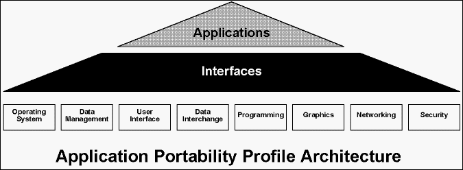
Although targeted for use of the federal government for its own development of GIS systems, the NIST has recommended APP standards as outlined in Table 1 and explained in the following paragraphs.
Table 1 - Applications Portability Profile
OPERATING SYSTEM SERVICES
- Kernel Operation -- (POSIX) FIPS 151-1, ISO 9945-1
- Commands and Utilities -- IEEE P1003.4, DPIS0 9945-2
- Real-time -- IEEE P1003.4 Security -- IEEE P1003.6
- Systems Administration -- IEEE P1003.7
PROGRAMMING SERVICES
Languages
- ADA -- FIPS 119, ISO 8652:1987 (approval without waivers)
- C -- X3J11/88-002 COBOL -- FIPS 021-2, ISO 1989:1985
- FORTRAN -- FIPS 069-1, ISO 1539:1980
- PASCAL -- FIPS 109, ISO 7185:1983
- CASE Environments and Tools
- Library Support
DATA MANAGEMENT SERVICES
- Data Dictionary/Directory (IRDS) -- FIPS 156
- (Army Regulation 25-9 Data Standardization)
- Query (SQL) -- FIPS 127, ISO 9075:1989
- Reporting
DATA INTERCHANGE SERVICES
- Documents
- SGML -- FIPS 152, ISO 8879:1986 (CALS)
- ODA/ODIF -- ISO 8613 (CALS)
- Product Descriptions -- (IGES) MBSIR 88-3813
- Graphics -- (CGM) FIPS 128, ISO 8632:1986
- Geographic Information -- Spatial Data Transfer Standards (SDTS) FIPS 173
- Meta Data
- Thematic Definitions
GRAPHICS SERVICES
- GKS -- FIPS 120, ISO 7942:1985 (CALS)
- PHIGS -- FIPS 153, ISO 9592:1988 (CALS)
USER INTERFACE SERVICES
- Client-server Operations (X Window Systems) -- X Consortium
- Version 11, Release 3 (FIPS 158)
- Object Definition and Management (X Window System) -- X
- Consortium Version 11, Release 3
- Window Management -- IEEE P1201
NETWORK SERVICES
- Data Communications -- (GOSIP) - FIPS 146
- Transparent File Access -- P1003.8
- Remote Process Execution -- P1237
Acronyms:
| CASE | Computer Aided Software Engineering |
| CGM | Computer Graphics Metafile |
| FIPS | Federal Information Processing Standards |
| GKS | Graphical Kernal System |
| GOSIP | Government Open Systems Interconnection Profile |
| IEEE | Institute of Electronics and Electrical Engineering |
| IGES | Initial Graphic Exchange Specifications |
| IRDS | Information Resources Dictionary |
| ISO | International Standards Organization |
| ODA/ODIF | Output Data Architecture/Output Data Interchange Format |
| PHIGS | Programmer's Hierarchical Interactive Graphic System |
| POSIX | Portable Operating System Interface for Computer Environments |
| SDTS | Spatial Data Transfer Standards SGML Standard Graphic Mark-up Language |
| SQL | Structured Query Language |
The APP architecture as shown below, adopted by the U.S. Army Sustaining Base Information Services calls for separating the systems application software from the overall computing infrastructure. This allows the applications to access computing services through a series of standard interfaces, data formats, and protocols. By separating applications software from the infrastructure, one can insert new computing technology as it evolves without having to rewrite the custom applications.
Operating System Services
The APP objective is to remove any dependence on vendor specific operating system software or hardware. The standard interface definitions should provide portability to the operating system environment independent of the hardware platform or the applications GIS software.
The NIST has adopted the Portable Operating System Interface for Computer Environments (POSIX) as a national standard for the operating system services. These standards define the functional interface between an operating system environment and the GIS software that conform to POSIX specifications as specified in the Federal Information Processing standards (FIPS) publication 151.
Programming Services
The APP Languages include ADA, C, COBOL, FORTRAN and PASCAL. These languages have NIST conformance validation tests to detect the correct interpretation of the source language by the compiler implementation. With the popularity of the UNIX operating system environment for both workstations and super mini-hardware platforms, the C-language is becoming a widespread de-facto standard. Currently, Computer Aided Software Engineering (CASE) environments and tools are getting more popular in software engineering and integration efforts. The Programmers Software Library support is another element of the APP programming services that provides reusable code for application and system development, and reduces the burden for configuration management. Language specific implementations of software libraries include data input-output and string manipulation, mathematical operations, graphics, task management, and network data communications. The standardization of this component is important in integration of application system development.
At this time, there is no mention of fourth generation (macro) language standards in the GIS application domain.
Data Management Services
The GIS interface to data management services often determines the extent to which a system is truly integrated across all data types, including spatial features and associated attributes. The interface also establishes a client/server relationship between user workstations and database server platforms. The use of standard interface definitions provides an effective facility for integrating GIS software with other applications software, as well as interoperability across database management software packages that conform to the standard interface specifications. The NIST has chosen Structured Query Language (SQL) and Information Resources Dictionary Systems (IRDS) as the key for conformance testing of data management services.
The SQL is the database language for defining, accessing, updating and protecting a relational database. IRDS is a software for managing data information. A standard data dictionary ensures data security, transfer, maintenance and integrity.
Data Interchange Services
The APP specifies several standards for data interchange, depending on the type of data to be exchanged. The following national and interspatial proposals are being discussed as standards for geographic data interchange:
- Authoritative Topographic Cartographic Information System (ATKIS)
- Canadian Council on Geomatics Interchange Format (CCOGIF)
- Digital Geographic Information Exchange Standard (DIGEST)
- Digital Line Graph (DLG)
- Digital Line Graph-Enhanced (DLG-E)
- European Transfer Format (ETF)
- Geographic Data File (GDF)
- Map and Chart Data Interchange Format (MACDIF)
- Mapping Interchange Data Format (MDIF)
- National Transfer Format (NTF)
- Spatial Archive and Interchange Format (SAIF)
- Spatial Data Transfer Standard (SDTF)
- Specifications for the Exchange of Digital Hydrographic Data - 1990 (DX-90)
The Initial Graphic Exchange Specification (IGES) was selected for the interchange of product description data. The Computer Graphics Metafile (CGM) was selected specifically for graphics data interchange.
The Spatial Data Transfer Standards (SDTS) was selected for interchange of GIS databases. The NIST recently adopted the SDTS as a Federal Information Processing Standards (FIPS 173) for geographic information which takes effect in February 1993. The federal agencies have until February 1994 to implement these data exchange and transfer standards. The SDTS's purpose is to ensure that no data is lost during transfer. Fidelity of the data and its relationships are preserved and there is full apprehension of the file after the exchange.
The NIST under the guidance of Federal Geographic Data Committee (FGDC) has also submitted a proposed draft on metadata standards for review by the spatial data user and creator community.
The FGDC has also formed several subcommittees to develop thematic definitions, and establish standards for base cartography, cadastral, cultural, geodetic, geologic, ground transportation, soils, vegetation, wetlands, international boundaries, and bathymetric data. The subcommittees draft reports are under review.
Graphic Services
Graphic interface often determines the system's portability and interoperability characteristics. The Graphical Kernal System (GKS), and the Programmer's Hierarchical Interactive Graphic System (PHIGS) are important standards for graphic services selected by NIST.
The NIST GKS test provides for five classes of tests including data consistency, data structure, error handling, operator display, and metafile tests for visual comparison between screen outputs and reference pictures.
PHIGS tests for consistent data structures and correct graphical screen displays using specific functions. To specifically address graphic systems performance, the Graphic Performance Characterization (GPC) Committee comprised of major industry sponsors, developed the Picture Level Benchmark (PLB). GPC members believe that no single performance value, such as Dhrystone, MIPS, Linpack MFLOPS, can adequately describe the performance characteristics of a graphic system. The ultimate GPC goal is to develop an application-level benchmark that would determine how fast different machines run specific user applications including graphics, windowing, input/output, and the operating system.
User Interface Services
User interface is the look and feel of a GIS system that users see and interact on their workstation computer screens. NIST has adopted the X-window system as the APP basis for standard user interface services. The server is the graphics display software that supports the user interface at the workstation. The client is the application software that communicates with the user by way of the X-protocol. This client software can be on the user's workstation or across a network on a different computer. In fact, multiple client applications executing on several different computers can communicate to the same user interface via the X-protocol. This provides great flexibility in allocating application software to workstations or services on a network and configuring overall system architecture.
NIST has a conformance test suite under development for the X-window systems. The X-protocol is tested for compliant communications and the data object definitions for consistency with the standard.
Network Services
The network interface is critical to linking multiple user workstations into a workgroup, and multiple workgroups within an enterprise. Local area networking is used to link individual user workstations into a local workgroup, usually across short distances. Linking individuals and work groups across longer distances is accomplished with wide area networking.
The national standard for networking is the Government Open Systems Interconnection Profile (GOSIP). The first version of GOSIP included the X-400 message-handling system and the File Transfer Access and management (FTAM) specification. The second version, GOSIP2, added features for remote log-in using Virtual Terminal applications. Other GOSIP specifications include X.44, X.25, transport, FTAM and 802.3 communications protocols.
For exact technical details on Federal Information Processing Standards (FIPS), write to:
NATIONAL TECHNICAL INFORMATION SERVICE
5285 Port Royal Road
Springfield, VA 22161
(703) 487-4650
